Walks Around Hagley

WALKS AROUND HAGLEY: WALK No.1 BLAKEDOWN

DISTANCE: JUST UNDER TWO MILES. TIME ONE & HALF HOURS. PARK IN BLAKEDOWN AND COMMENCE THE WALK AT THE STATION (O.S. MAP GRID. REF. 881787)

The Station

The railway was built in 1852 by the Oxford, Worcester and Wolverhampton Railway Company, known to locals from its initials and many misfortunes, as the Old Worse and Worse. Walk to the main road (A456) and turn right.

Little Champson

A short way on the right is a house, Little Champson, built in 1835. The first owner was a gentleman farmer from Great Champson, in Gloucestershire. The original front door was probably blocked in.

The Church

Cross the main road (with care) and you find the Church on your left. The Church of St. James the Great was built as a Chapel of Ease in 1860 (for the ease of those who previously had to travel to St. John’s Church in Hagley). The old school lies behind the Church. This school was established in 1885. The architect was Mr. T. Grazebrook and cost £400.

Village Street

Walk along the main road towards Kidderminster as far as the junction with Belbroughton Road. On the left-hand side is Rose Cottage (1820) which was a shop until 1955. Sylvester’s Grocery shop used to be on the corner on the site of the Toll House. A Toll Gate once blocked the road here, where the Birmingham – Blakedown Turnpike ended. The haulier, Mr. Hyde, took axles from Spring Brook Forge to the Station along Forge Lane and The Avenue, which he constructed to avoid paying tolls of a half a penny a load.

The Honey Farm

Just round the corner in Belbroughton Road, and linked to Rose Cottage (in 1977 the two were joined by roofing over the central cobbled yard) is the Honey Farm. This was a Blacksmith’s in 1900. The small window was the brazier and the large window was the stable door. (Note brackets) In the. Second World War it was a builder’s yard. The Honey Farm was set up in 1950 and by 1976 Honey was being processed here from 600 hives in Herefordshire, Shropshire, Worcestershire and Staffordshire.

White Cottages

Cross Belbroughton Road to the white cottages. These were built c. 1837. The single storied building was previously a slaughterhouse; inside is a (now concealed) main timber post to which animals used to be attached. Turn into Forge Lane, between the cottages and “The Old House at Home”.

Forge Lane

Walk along Forge Lane past “The Old House at Home”. (first licensed in 1873) on the right are some old cottages. There were once more cottages but these were demolished for extensions to “The old House at Home”. 2, 4 & 6 Forge Lane were built for workers at the forge. Forge Lane is a regulation l8 feet width, as decreed by the 1832 Enclosure Act. Continue along the lane to Forge Pool. (This is hidden by the trees).

Spring Brook Forge

A glimpse of Spring Brook Forge across the pool and through the trees (in Winter), makes it seem incredible that, at the turn of the century, 150 men were employed there. It is a listed building and private property. In the distance you may just be able to see race, sluice, pentrough and wheel.

Churchill Lane to Mill Lane

You can continue along Churchill Lane to the Mill, but to avoid dangerous traffic in the narrow lane, turn right into Wannerton Road. A short way along is Wannerton Brook. Next turn left into Brookside Way. A path leads from the end of Brookside Way to Mill Lane. Turn left at Mill Lane to see Churchill Corn Mill.

Churchill Corn Mill

The dam survives in the garden, a 52m. (57yds.) horse-shoe of brick and earth construction (details in “Watermill sites in North Worcestershire). The mill machinery was sold for scrap in 1940. Window arches suggest an early 19th century date. Large and small millstones left in the garden suggest both corn milling and edge tool grinding.

Return to the Station

Walk back along Mill Lane to Blakedown Station. Across the railway lines and to your right are railway cottages. These were built to house the Station Master and Porter. Later they were also used to house the Signalman. In 1994 a Signalman still lived in one of the cottages.

Forge Pool & Ladies Pool

Follow the footpath along the edge of Millennium Green and parallel to Forge Pool. The pool ends in a marshy area. At the edge of this there are coppiced alder trees in the mixed woodland. Turn right at the “T” junction with the next path and cross the dam to the Ladies Pool. There was a flood in 1848 when this dam burst. Fortunately the Forge Pool held the water for 15 minutes, warning reached people downstream and there was no loss of life. N.B. The notice board by the Ladies Pool gives some of the history of the pools and the wildlife.

Halfshire Lane & Swan Pool

Continue uphill on this path leading to New Wood Farm (10 feet wide as specified on the 1832 Enclosure Act.). Turn right on reaching New Wood Lane and shortly right again down the bridle path. The raised banks and hedges on each side suggest a boundary. As the path meets Halfshire Lane the Swan Pool can be clearly seen on your right and across the pool look along the Viaduct to your right to see the remains of the red brick supports for the earlier wooden Viaduct. On the left is a modern garage marking the sight of the Smithy at the bottom of Halfshire Lane. This lane was originally part of the main road from Blakedown to Kidderminster prior to the Turnpike Road of 1777, which linked Kidderminster to the Blakedown Birmingham Turnpike Road of 1753.

Viaduct

Cross the A456, to the left of Churchill Lane a modern black and white house replaces an old timber framed building. Along the Viaduct here is another red brick support of the old wooden Viaduct. On the right hand side of the lane Mill Cottage (modern building) garden now has a dry brick conduit coming under the road from Swan Pool. Blakedown Mill disappeared from this place in the road widening done c.1920.

Viaduct & Other Old Sites

Pass under the Viaduct. On the left was Blakedown Sawmill (private property) originally this was on an island made by the stream from Churchill (still visible) and the tail race (now dry) from Blakedown Foundry. This was in operation up till 1951.

Download

DISTANCE: APPROXIMATELY TWO & A HALF MILES. TIME: ONE & A HALF HOURS. PARK ON WASSELL GROVE ROAD BETWEEN THE COUNTRY CLUB AND THE FOOTPATH (O.S. MAP GRID REF. 932823).

N.B. A compass is useful. Bare legs not recommended.
  1. From Wassell Grove Lane cross stile and take footpath diagonally across the field (NOT along the hedge). Just inside the field are two house platforms, the “Tenement” shown on the 1837/8 Tithe Map. (Note: references to platforms etc. depend on grass being cropped.)
  2. Remains of pond possibly associated with farmhouse. Ridge and furrow visible.Wassell Grove Farmhouse
  3. Wassell Grove Farm. Grade II listed building. Brickwork shows top storey added later. 18th century possibly altered early 19th century. Barn dated 1826.
  4. More ridge and furrow. Pond and dried-up stream. Old hedge.
  5. View Point: Rowley Hills E., Leasowes E., Frankley Beeches S.E., Dudley Castle and Top Church E.N.E.
  6. Steps mark geological fault line and also the parish boundary between Hagley and Wollescote.
  7. Enter Council Estate built 1931 by Lye – Wollescote U.D.C. via Ashfield Crescent to Wynall Lane. Leave shops on your left at island. Footpath on R. opposite Sensall Road, signposted Lutley.
  8. Foxcote Farm on L. Farmhouse c.1900.
  9. Foxcote House Farm R. Grade II listed building, model example of a Georgian farm complex c.1794. Note blocked-in windows presumably because of window tax (1696-1851). View Point: Oldnall and Beechtree Collieries N. near Oldnall Road, Caslon Wood and Primary School N.E.
  10. Cross Foxcote Lane and over stile down fore draft. Note evidence of coppicing hazel nuts.
  11. Foxcote Pond. Mentioned in Anglo-Saxon Charter. Boundaries of Lutley, Cradley, and Oldswinford all met nearby. Ridge and furrow visible. Balk on mid-slope indicates division of two main blocks of medieval Open Field System. Mesolithic flints found here and in vicinity.
  12. Cross over stile on R. Grange Farm on L. Possible house platform(s) in field.
  13. Cross road to Grange Farm Cottage. Follow public footpath at side, part of hedge marks Hagley Lutley border.
  14. Modern fishponds visible through chain link fence on L. as the path turns W. towards the next section.
  15. Old hedge, including field maple. Stile. Entrance driveway to modern fishponds on L.
  16. Wall skirts Wassell Grove House estate. Old house (Georgian with large Victorian extension) now replaced by two modern ones. Brick walled garden. At the end of the 18th century Wassell Grove House was the residence of Daniel Rogers. Later owned (together with a great deal of the surrounding land) by John Richards, High Sheriff of Worcestershire 1844. In the latter part of the 19th century owned by Job Garrett J.P. During First World War administered by Birmingham Board of Guardians as Convalescent Home. Bought 1958 by the builders who demolished the old House and built two modern ones.
  17. Stable block of old Wassell Grove House converted to modern mews dwellings. Dovecote in roof apex retained. Stables used to house a theatre c.100 years ago, when owned by the Garrett family.The Lodge
  18. Old stone wall on L. probably pre-dates the Georgian Wassell Grove House. Remains of foundations were found by the builders when constructing the driveways to the two modern houses. The entrance drive lower down the lane is of fairly recent construction although it reuses the old stone blocks. The old wall of similar stone on the R. has a brick infill at a point which may mark the entrance to the old tenement, the platform of which was noted at the start.
  19. The Lodge, situated at the former entrance to Wassell Grove House, is of cottage orné style, not marked on the Tithe Map of 1837, probably mid-19th century built rather late for the style.
  20. Clent Villa Farm 18th century with later additions.
  21. Near entrance to Hagley Country Club is site of mobile home complex existing until 1960’s – early 1970’s when the Club was opened.

DOWNLOAD THIS WALKMap of Walk 2

DISTANCE APPROX. 3 MILES. TIME 2 HOURS. PARK IN BRAKE LANE ON PULL IN (O.S. MAP GRID REF. 894806) Diversions add time and mileage.

  1. Turn left into the path next to “Chimneys”, between double hedges. The width is 15ft. as in the tithe Award of 1938.
  2. As the path reaches the open field, once divided by a hedge going up from the gate, on the right you can see Brake Mill Plantation. The steep dip in the field to the left is a geological fault. A better view is obtained by diverting to the L. on the path by the farm, as far as the stile.Four Ways at Brake Mill Farm
  3. The Miller’s cottage on the R. and the farmhouse on the L. were built by the Railway Company c.l850 because the original cottage and farmhouse were destroyed when the railway was constructed. The path to the L. of the cottage, as you face it, is on the route of the Roman Road connecting Droitwich with Greensforge and Watling Street.
    Diversion A
    A short walk down the tarmac drive gives a close look at Brake Mill and the Pool, separated by the Dam. Sweetpool and Brakemill Pool were made in 1543.
  4. Return to the farm and take the path to the left behind it to Stakenbridge, following the Wannerton Brook along the valley. From this path you can see the rear of Brake Mill, the tail race and, if you look very carefully, you can see some brickwork in the bank of the stream which is, presumably, the ruins of the cellar of an earlier house marked on the Churchill tithe map.
  5. Walking past the marshy ground where the stream and tail race meet you continue on to Stakenbridge Pool, described as the “New Poole” in 1589. In 1994 new paths and boardwalks were made round the pool.
  6. To your right is Stakenbridge Farm, converted c.l987. In 1940 Kelly’s Worcestershire Directory it is described as Stakenbridge Riding School run by Capt. Rupert Bache.Churchill Forge
  7. Once over the stile, cross the road. A little to the left are a few remains of Stakenbridge Forge, a Spade and Shovel Works, which ceased working after the second World War. Traces of a sluice and some brickwork are still visible but a recent pool covers the site.
  8. Turn back past Stakenbridge Farm then fork left onto the path to Churchill. On the rise to the right is Churchifi House. The original part was built in 1740 for the Estate Manager to Sir Thomas Lyttelton.
  9. On the left of the path is Churchill Pool. The path skirts the edge of it through the kissing gate by the overflow sluice, then over the low stile and turn left unless diverting.
    Diversion B
    Continue straight ahead to Churchill Lane, then turn right and walk to the crossroads. There one can see: (i) The War Memorial (on the left) (ii) Churchill School on the crossroads built 1895 closed 1961 and now a private house. (iii) The Village Hall, next door, which was built as Churchill’s school c.1798. (iv) The Pound is to the right, on the left side of Stakenbridge Lane, it was erected in 1862. Return to the low stile and turn right.
  10. On the dam you can see the sluice to the forge and to the right is a good bird’s eye view of the forge itself and an explanatory notice.
  11. Continue along the dam, then turn right between the house and the cottages. The path has fencing on the left and the stream and tail race on the right which join at the modern bridge. You cross the stile and the old bridge to Churchill Lane.
  12. On the left is Bridge Cottage first part built in 1730, the second cottage, built later sideways to the first. It was once a Cider House and is shown on the Tithe Map of 1838.The Church of St. James the Great
  13. Ahead is a good view of the Church of St. James the Great. It was built In 1868 to replace a thirteenth century (with later additions) church
  14. Turn right opposite the church, past the barn conversions, Old Church Farm House is on your left. Cross over the second stile on the left then diagonally across the field, called “Backside” on the Tithe Map, (Possible ridge and furrow) heading up the slope for the conifer on the left to find the next stile. As you climb look back at the excellent views of Churchill and Harborough Hill.
  15. Cross the stile and you are in “Crab Tree Close”, then “Cooks Furlong” before reaching the remains of the double hedge. This divides “Shoulder of Mutton” and “Poole Piece” from “Parsons Field” which is behind Glebe House, once the Rectory. All these fields were in “Churchill Field” which was one of the three Common Fields of the Middle Ages, the other two being “Whitnell” and “Neyther”.
  16. Cross Rocky Lane and follow the path at the edge of the field onto the ridge, where there are splendid views. First on the right views of Wychbury, Clent, Walton and Lickey Hills. Further along a glimpse of St. John’s Church, Hagley and Hagley Hall. Look left to see ( from left to right) the Clee Hills, Kinver Church and further over, on a clear day, the Wrekin.
  17. On reaching the North Worcestershire path (marked on posts) turn right, downhill to Iverley Lane. The farm to the right is Common Farm which was established soon after the common land was enclosed in 1774.
  18. Cross Iverley Lane and follow the path that is the unmetalled part of Brake Lane. Notice the width between the hedges, (30ft). This was because It was designated a public carriage way in the Enclosure Award, possibly an alternative route to Stourbridge.
  19. Just past the lowest point of the lane you can see the remains of a brick wall in the undergrowth on the right. On the Hagley Tithe Map of 1838 four houses and gardens are shown here.
  20. In the field on the right is some brickwork known locally as “The Butts” because shooting was practised here by the Home Guard during the Second World War.
  21. On reaching the ‘T’ junction turn right and shortly turn left and continue along Brake Lane to your starting point. On your right as you go is Palmers Hill and the farm to the left is Upper Brake Farm which is a Victorian building marked on the 1884 O.S. This is on land enclosed in 1832 but the farm dates from the 1860’s because the field next to the lane was not sold to the Lytteltons until then.

DOWNLOAD THIS WALK Adobe DownloadMap of Walk 3


DISTANCE: ONE & A HALF MILES. TIME: MINIMUM 1 HOUR. PARK: BY PARISH CHURCH (O.S. MAP GRID REF) 921802

  1. R. The present Church buildings are mainly Victorian, 1857-1860. Designed by G.E. Street in 13th. century style, but on ancient site. Worth a visit.
  2. L. Hagley Hall. Palladian mansion built 1754-1760. Designed by Sanderson Miller for Sir (later Lord) George Lyttelton.
  3. R. Cricket pitch, site of the original half-timbered Hall. The old main road to Birmingham reputedly ran between the Old Hall and the Church before the present Birmingham Road was turnpiked in c.1753.
  4. Look back R. to the “Prince's Pillar”, commemorating Frederick, Prince of Wales, son of George Il. Sir George Lyttelton was Frederick's Secretary 1730 – 1740's.
  5. Private Gardens of the Hall.
  6. Turn R. to Stables, built 1940's. Conversions to workshops etc. 1984. Inside courtyard note Clock dated 1951; Weather Vane; 2 original iron Lantern Holders; Cobbles.
  7. Car park is the site of 18th. century Laundry, pulled down 1957. Small Temple to rear originally a Summer House, containing stained glass windows illustrating “The Seasons” by 18th. century poet James Thomson.
  8. Return to Hall Drive. Wall on L. is the Ha-Ha (or sunken fence) to the garden in front of the Hall.
  9. R. The pointed window in the Stable-block wall marks the Hall Barn, formerly used as a Church Social Room. Note ventilation holes of the Barn
  10. R. Look up to attractive Lantern tower supporting Weather Vane, Walls show signs of conversions
  11. L. Ice House. Domed brick construction. Before refrigeration, ice used in the hall would have been kept here. (Overgrown in Summer)
  12. R. The Cot: probably servants cottage to:-
  13. Park House (no nameplate). Possibly late 18th. century. A listed building with nice decorative ironwork to the porch. Former Rectory, 1949-1979.
  14. L Modem Lodge to the Hall. Notice the remains of the avenue of trees in the field (some felled in 2000) leading up from the Bromsgrove Road to the Lodge, alongside the present road. Turn L. for a short way along the footpath to Clent. V. P. for views of Malvern/ Abberley/ Clee Hills.
  15. Hedge marks Parish boundary. Return to Lodge.26-28 Hall Lane
  16. Drinking fountain. Cast iron, marked “J. Kennedy Patentee”, possibly older than the brickwork which is dated 1914. Turn into section of Hall Lane which runs towards the Birmingham Road. Walk for a short distance to: V. P. for view of the Obelisk (some dispute as to who erected this either Admiral Smith or Sir Richard Lyttelton) and the Temple of Theseus, 1758, first of its kind in the 18th. century English Landscape Park.
  17. L. Modern ElI Pillarbox (Square locked box to house excess postbags during deliveries).
  18. Complex of 18th. century cottages. Note “Sun” Fire Insurance Plaque on No. 28.
  19. R. Scout Hut opened May 1978 on former site of allotments to School in School Lane.
  20. L. Site is marked “Hop Meadow” on 1837 Tithe Map.
  21. R. 18th. century building: remains of Bostin's Butchers Shop and Premises. Much altered.
  22. L. “Old Coach House” possibly 18th. century.
  23. R. Row of 18th. and 19th. century houses and small courtyard of cottages. Possibly at least one “Ale House” here originally.
  24. Continue R. into Hall Meadow. A. Site of School built by Lord Lyttelton 1827, now occupied by 2 modem houses. The path at the side leads back across Hall Meadow to the Stables and Hall.
  25. R. Some Lyttelton Estate houses amongst more recent housing development.9 to 23 School Lane
  26. Return to School Lane. “The Hurst” Interesting Victorian house, enlarged at some time, now divided. Continue along School Lane to Birmingham Road. Turn R. up hill to a point opposite Monument Lane.
  27. Small cottages probably housed servants to the larger mansions. Next 4 houses, 2 semis and 2 detached, are all listed Grade II buildings. Late 18th or early 19th. century. Note G. R. pillarbox in the wall.
  28. Behind shrubbery, “The Lawns” c. 1840's, A former Rectory prior to “Park House” in Hall Drive.
  29. Elm Lodge, used for a time as a private School. 1980's reconstructed facade. Original early 19th. c.
  30. Return down hill to opposite “Rockingham Hall”. Former Dower House. Original building late 16th. early 17th. century. Several periods of alteration and extension in the 18th. 19th. and 20th. centuries. Now divided into flats.
  31. The Orangery, now 2 houses, once part of Rockingham Hall Estate.
  32. L. Cottage on the triangle of land, reputedly built from the same stones as the present St. John's Church (1850's).
  33. L. Site of the old Cattle market. Used till 1950's.
  34. L. “The Spensers Arms”. On site of an Inn named to commemorate marriage of Wm. Henry (later 3rd. Lord) Lyttelton to Sarah Spenser in 1813.
  35. L. Old cottages converted to shops. The General Stores is the present Hagley Post Office.
  36. Pair of cottages, possibly 18th. century Blacksmith's house.
  37. Walk a short way into Bromsgrove Road. L. Pair of early 20th. century cottages.
  38. Former Police Station built 1930's. Return to the main road.
  39. The Garage Showroom is the site of the old village Forge. The road .here was once Middlefield Lane, becoming part of Kidderminster Road in the 1920's when a new section was constructed to intersect Park Road.
  40. R. Telephone Exchange. Note ultra-modern signalling equipment.
  41. R. Start of present day Middlefield Lane.
  42. R. Modern Police Station to replace the one in Bromsgrove Road.
  43. Bear L. at large island, feeder road to M5 built 1964, note War Memorial opposite.
  44. L Memorial commemorating the Grazebrook Diamond Wedding 1905. Originally sited in the centre of the cross roads near the Cattle Market. V.P. Views to Malvern, Abberley & Clee Hills.
  45. Turn L. to upper part of Park Road. L. Council houses c. late 20's and 30's.
  46. Site of the Lyttelton Arms Stables.
  47. R. Lyttelton Arms, now a Harvester Restaurant, variety of periods from the 18th. century onwards. Old Coaching Inn, known locally as “The Taphouse”.
  48. Turn L. into Bromsgrove Road a short way. L. the old Post Office was at No 20.
  49. R. No 29 Lea Cottage, home of a 19th. century village Infants' School, Mistress Mrs. Wooldridge, wife of the Blacksmith at the Forge.
  50. R. No. 25 originally a Workingmen's Institute, since converted into a house.
  51. R. No 23 Former Infants' School, 1856 – 1937.
  52. Return to the cross roads. Below the Harvester Restaurant is Beacon Hill House, 18th. century.
  53. Turn L. into Hall Lane (Once known as Park Lane). The house on the corner was originally a shop, 18th. century.
  54. L. Furlong Cottage, note barge boards, decorative tilework and drip mouldings. Probably added mid-19th. century in revival style.
  55. Highbury Cottage, square shaped extension was built in double cube proportions in 1930's. Rest of the frontage appears to be 18th. century, original building late 16th or early 17th. century.
  56. No. 48 occupies the site of a Malthouse on the 1837 Tithe map which was used for brewing by the Lyttelton Arms. The Malthouse was built as a Glasshouse to manufacture bottles in the late 17th. century by Paul Tyzack II and John Pagett. Return up Hall Lane then Hall Drive to the Church

DOWNLOAD THIS WALK Adobe DownloadMap of walk 4


DISTANCE: THREE MILES. TIME: 2 HOURS PARK IN THE LAY-BY ON THE A491 JUST BEFORE THE TRAFFIC LIGHTS AT THE TURN FOR BELBROUGHTON (OS MAP GRID REFERENCE: 936775)

  1. Walk down to the traffic lights, cross the road and proceed down Hartle Lane (B4188). The building on the left was once the storage building to Bell End Mill. The Mill had started as a Cornmill and became a Scythe Grinding Mill from the early twentieth century until 1949. The Mill and its dam disappeared under the road-widening scheme of 1963.Bell Hall
  2. Walk along Hartle Lane, passing a lodge to Bell Hall. The stream on your right is the Belne Brook or Rum (or Ram) Alley Brook, which has risen in the Romsley Hills. On your left you see Bell End Chapel, dating back to the twelfth century, so being one of the oldest buildings in the area. It shows work of Norman and perpendicular styles and is still in occasional use.
  3. Further along Hartle Lane, on the right, see Galton’s Mill, sluice and now drained pool. The overshot wheel still exists but is not visible from the road. This started as Savage’s Mill, corn grinding until Galtons used it for grinding gun barrels during the Napoleonic wars. In the mid-nineteenth century, Isaac Nash took it over for Scythe Grinding until 1942 when it became an engineering factory. Today it functions as an office.
  4. Take the first stile on the right, walk diagonally across to another stile, and turn right to the first of three twentieth century fish ponds. Look out for herons, swallows etc.Middle Mill
  5. Turn left along the pools. Soon you will see a tree-topped earth bank parallel to the path, separating the pool from a head race, which once fed water to Middle Mill. This Mill complex is immediately over the next stile, with the dam and sluice on your right and a few inconspicuous bricks from the Mill building on your left. On your right are two areas set out for water sports. Middle Mill was working until 1953 as a Plating Mill, operated by Eddie Moore, see the tail race on your left overflowing at various points back into the stream.
  6. Walk in a curve to the stile on the right. Continue, keeping to the left, to a stile in the trees. Follow the fence and then a hedge to another stile. Turn left. A short diversion over the stile on your right will take you up to the remains of Belbroughton Blade Mill in the grounds of Yew Tree House.
  7. Continue the walk and on the left of Dark Lane, at Fieldhouse Farm, is an interesting building, perhaps stables and a coach house. The overflow on the right comes from the garden of Yew Tree House where the pool of Belbroughton Corn Mill is sited.
  8. Reaching the main road, look to your left to see an unusual Belbroughton name plate in a garden on the right, presented by the WI in 1938. Cross the road to a narrow public footpath. Walk along it to a direction post and turn left. Across a tarmac track is the original site of the internationally famous Nash Main Works, known as Belbroughton Scythe Mill.
  9. Follow the narrow path past a weir made of two rows of millstones and then a rockery between two branches of the stream. This rockery is the site of another mill where coarse cloth and then corn had been processed until Nash converted to a hook and scythe grinding, glazing and polishing works. By the turn of the century it reverted to corn grinding and was demolished in 1928.
  10. Turn left and with the Queen’s Hotel on your left, cross the road and take the road to your right up Church Hill. On the right are 18th. century Almshouses which became the village workhouse between 1825 and 1837 later licensed and known as “The New Inn” and now a private residence.The Old School House
  11. The next building was built in 1760 as a single storey School for Boys and in 1850 an upper floor was added to provide a School for Girls. The building remained as a School until 1963, then became a private residence, and was later restored in 1979.
  12. Follow the road round. Holy Trinity Church is on the right. It has work of Norman and many later periods. On the wall of the Church grounds, at the junction of Church Hill and Church Road, is a tablet carved by local craftsmen which was erected by the Parishioners of Belbroughton to mark he Millennium as a tribute to the Scythemakers of Belbroughton. Isaac Nash’s Great-Great Granddaughter Sallie Mahler, unveiled the tablet on 24 October 1999.
  13. Opposite the Church is Royden House, 19 Church Hill – built in the late 18th. century. Between 1889 and 1910 it was used as a Charity House for “waifs and strays” (i.e. an orphanage) and was known as “All Saints Home”.
  14. Cross Church Road to see the Church Hall, an early 17th. century timber-framed Tithe Barn which was converted to a Hall for the Community in 1915. Look down the hill to see a Black and White timber-framed house, Belem Cottage. This was originally three cottages built in the 17th. century, the oldest house in the village, and well worth a diversion.
  15. Next to the Church Hall, going up the hill, has been the site of the Rectory from the 16th century. The present 18th century building was a Rectory until 1976.
  16. Walk up the hill and turn left in front of the Belbroughton First School. Continue along the footpath, pass the Tennis Courts (on your right) until you reach the main road. Go through the gate, turn right and walk back along this main road, to your starting point, looking for the timber-framed buildings and views of Bell Hall on your right.

DOWNLOAD THIS WALK Adobe DownloadMap of Walk 5

DISTANCE: 3 MILES TIME ABOUT TWO AND A HALF HOURS. PARK IN NIMMINGS CAR PARK (PARKING CHARGE) (O.S. MAP GRID REF. 938808)

Abbreviations: Compass points = N.E.S.W.   ridge and furrow = r & f  Directions left or right = L.R.   century = c.

  1. Leave the car park by the vehicle entrance and cross the stile almost immediately opposite.
  2. Straight ahead, across field, down bank where r & f is visible, shortened now. Perhaps a relic of the medieval open field system of farming. Proceed down field diagonally R. Large quarry on R surrounded by trees. Continue to gate beside a cattle entrance. Muddy in wet weather. Bear R. after the gate, more r & f can be seen.
  3. Pond on R. continue for short distance then R. again. Meet wide old track to the old Penorchard Farm.
  4. Make short detour L. down track. On L. note house platforms in field. Beyond are mined l7th.c. sandstone outbuildings. of old Penorchard Farm, perhaps quarried near site. The 1838 Clent Tithe map and schedule shows the owner as John Amphlett and occupier as George Whittaker, with mixed farming. Return up old track to stile.
  5. Climb stile into field. Cross field noting old track to original farm mid-field; remains of aid gate posts in far hedge. In next field (Chapel field) note house platforms on R. behind church. R & f visible on L.St. Kenelms Church
  6. Over stile into St. Keneims churchyard. Although the church is ancient the first burial in the churchyard was in 1857, earlier burials being in Halesowen.
  7. The church is dedicated to St. Kenelm, a figure surrounded by legend and mystery. Son of Kenuif, King of Mercia 796-821, the 7 year old Prince Kenelm was allegedly killed near this spot at the command of his elder sister Quendryda in an attempt to seize the throne on their father’s death. Legend tells us that Kenelm’s body was hidden under a Thorn bush by his murderer and discovered only after a mystical appearance to the Pope in Rome of a dove bearing a scroll written in Anglo-Saxon and telling of the murder. This story is mentioned in Chaucer’s Canterbury Tales (The Nun’s Priest’s Tale), and merited a translation of the scroll by John Milton as: “Lo. in a mead of kine, under a thorne; of head bereft, lieth poor Kenelm, King born”. When the body was exhumed for reburial at Winchcombe Abbey, legend has it that a spring of pure healing water gushed from the ground. The site became a place of pilgrimage and led not only to the later building of St. Kenelm’s church but also the growth of the nearby medieval village of Kenelmstowe (see map). The village declined after the reformation when pilgrims ceased to visit the spring. The present church was started in the 12th. c., enclosing the original spring in its undercroft. Later the water drained away, or was channelled, and emerged lower down the hillside. The church is worth a closer look from the outside. Entrance to the interior is restricted. Approaching from our path (&) you will see the W. Tower c.1475 (grey sandstone), standing forward of the older 12th. c. Norman wall (red sandstone). Note gargoyles at W. Angles and corners of church roof. The NW buttress has a small incised 15th century consecration cross. SW buttress, empty niche once contained a carved figure. Continuing round N. wall, note two blocked-up doorways: central one porch demolished in 1846 restoration, the other was a priest’s entrance. Return to main path round S wall: Tudor porch c.1550. Tympaniurn, Norman c.1150, possibly work of Herefordshire school of carvers. Note high on S. wall to E. of porch carving of figure, reputed to be St. Kenelm. Formerly inside the church hence its excellent condition, of early date. A little further to E., the blocked-off doorway which once led down to St. Kenelm’s well in the undercroft. A detour can be made to the Lych Gate, erected c. 1919. Along road is Chapel Farm, built 1868 on site of earlier farmhouse.The Porch of St. Kenelms Church
  8. Follow path to E end of Church to landscaping of St. Kenelm’s spring. The sculptured wooden posts in the area were the result of a collaboration between the N. Worcestershire Countryside Action Project and local school children who designed them. Note also rag-adorned tree lower on L near an alternative spring in bank. Presumably a modern version of medieval custom at healing springs such as St. Kenelms. Pilgrims seeking healing would hang their bandages, on a nearby tree before bathing the affected part, hoping for a cure by the time the bandages disintegrated.
  9. Our path follows the L hand bank of a deeply cut stream which starts from the well, joined by other springs, and other streams lower down. This forms one source of the River Stour. Through 2 gates note information board on Penorchard Meadows Nature Reserve. R & f visible L hedge at top field may be old open field boundary. Pass into next field.
  10. Note small concrete entrance to culvert R which carries stream under Elan Valley pipe line aqueduct.
  11. Aqueduct itself crosses a short distance downstream, carrying water from Wales to Birmingham. Note sturdy iron railings. Stables and road on R a few yards below, stream emerges from its culvert under the aqueduct. Pass over stile now used as a fingerpost then through gate in hedge. Follow hedge on R. r & f in field L road on R. Uffmoor Wood beyond that.
  12. Follow meandering path through woodland. Bogs Wood visible on L. Cross stream R barbed wire fence L note hurdle horse shelter R.
  13. Field Cottage Farm on R. Look back for pleasant view just walked.
  14. Clent SkylineBridle path. Our way is L, ignoring the arrows invitation to go R after a few yards. Good view of Clent.r & f both sides of track. After short distance turn onto narrow fenced path to skirt Bogs Wood. 2 stiles.
  15. Bank on R is spoil heap of Elan Valley pipe line. Through kissing gate and follow path through to next field. Follow R hand hedge r & f visible near edge of field on L. Over stile L.
  16. Skirt R edge of field. R & f both sides. Go through gap in holly hedge and through 1 kissing gate. Note late r & f going down to the main road (broader than seen previously). These fields on R are part of the eastern-most edge of Hagley Parish. Continue on, keeping to lower edge of field.
  17. Waterworks buildings can be seen up on L, down on R.
  18. Over stile. Cross over Hagley Wood Lane, through gate opening.The Monument on Wychbury
  19. Skirt Hagley Wood, mentioned in Doomsday survey 1086 as being half a mile long and 3 furlongs wide. Note view of Clent on skyline L. Ignore the first stile on L but cross the second on L., marked with warning to keep dogs under control.
  20. Up steep field. Through kissing gate.
  21. Pause to look at Nature Reserve created round old farm pond (or possibly old quarry site) L sheltered spot with seats and explanatory board re Robbo’s Pool. Continue climbing.
  22. Note board explaining “Stu’s Spinney”. Through kissing gate.
  23. Up more slope and through gate into Nimmings Car Park, Turn and look NW for view over Wychbury Hill (site of an Iron Age hill fort) and the 18th. century obelisk.

DOWNLOAD THIS WALK Adobe DownloadMap of Walk 6

DISTANCE 3 AND A HALF MILES. TIME ABOUT 2 HOURS. PARK EITHER AT THE SIDE OF THICKNALL LANE OR NEARBY (O.S. MAP GRID REF. 903793) Notes nettles in high Summer and large dogs will have to be lifted over the first three stiles.

  1. The walk begins at the lane opposite Thicknall Farm. There is proof of a dwelling here from the 14th. century, William de Thickenol was mentioned in 1327 and Henry Thykenol in 1400. Ticken means young goats (perhaps also lambs) so the farm was possibly the residence of the shepherd who grazed the animals on the adjacent Clent Heath. Walk along this lane and turn left at the T-junction, in a few yards cross the stile on the right and follow the footpath, with the, fence on your left, to the two stiles. Cross these so that the hedge is now on your right.
  2. There are views of the Clent Hills as you walk to the next stile, onto a track where you turn right.
  3. Before you take the next turn right stop and view Red Hall Farm. The present house was built in. the late 17th. or early 18th. century using some materials from previous houses on the site. The evidence leads to the assumption that there was a part sandstone and timber-framed building on the site. The name Red Hall means Red Spring and the site has been occupied since 1373, when it belonged to Black Ladies Priory, Brewood and was tenanted by John de Dunclent and his wife Alice.
  4. Turn right passing the millstone in the bank. Along this lane on your left is Old Well Cottage, formerly Broome Farm. It is the black and white cottage with a cider press in the side/back garden.
  5. At the junction stop. Broome House (now a private retirement home) is on the left, on the right is the Old School House and beyond it is the Parish Rooms (previously Broome School built in 1889 and closed 1933).The Parish Rooms
  6. Go straight ahead and through the Church yard. The present Church of St. Peter was built in 1780 with 1861 additions, it replaced a medieval church. One of the Rectors was Thomas Dolman, who married Mary Penn from Harborough Hall in 1726, her sister Anne was the mother of William Shenstone the poet and landscape gardener famous for his grounds at the Leasowes, Halesowen. Rejoin the lane.
  7. Notice the bargeboards on Rose Cottage by the Junction. On the left nearest the junction is Dower Cottage, partly timber framed, which was the temporary Rectory between 1921 and 1924 whilst. the new Rectory was built.
    Optional Diversion. Turn right to view Broome Farm on the left, note the road sign! Either retrace your steps or circle the centre of Broome.
  8. At Dower Cottage take the road to Churchill. Note the boundary wall of the Old Rectory. Look for Lords and Ladies in the hedge opposite (in season.) At Hundredacres Farm take the footpath over the ditch and stile, diagonally across the field to the next stile on the A450, which cuts a corner
  9. Cross the road to the footpath opposite. Just before the path crosses the end of the first field you are passing over the route of the Roman road between Droitwich, Greensforge and Watling Street. Pause at the gap in the hedge for lovely views of Romsley, Walton, Clent and Wychbury. The Hall, Church spire and the Monument at Hagley can. also be seen.
  10. Continue to the T junction at the foot of the steep bank through the wood. Turn right on the far side of the hedge and follow the path to Broome Mill.
  11. One pool faces you, but is fenced off, turn right, on your right is Broome Mill, now a modernised house. When on the tarmaced drive the raised bank on the right is the dam of the pool which supplied the water for the mill.
  12. Follow the drive to the A456. The 5 acre field on the right, known as "Poor's Land" raised money for the poor by rent or crops until 1949.Broome Church 1793
  13. Cross the A456 to the footpath by Harborough Farm. Built between 1832 and 1838. but recently extensively altered. The two cottages on the hill to the left are older.
  14. At Stakenbridge Lane turn right. The Post Box outside Yarnold Cottages shows which one was once a Post Office. Railway Cottage is one of three built c. 1852.for railway employees. Bay Tree House now stands where cottages for the poor were built in 1805, but sold in 1836 when the poor were sent to Bromsgrove Workhouse. Not a change for the better!
  15. Dammas House recalls the fact that Dammas Hall was situated on that corner.
  16. The raised bank on the right of the road, just before the houses begin, is the remains of a tumulus, one of a group excavated by Bishop Lyttelton in the 18th. Century.
  17. On reaching the A456, on your right is Daisy Cottage. In 1838 this cottage & shop belonged to William Price. Cross the road carefully, into Thicknall Lane, then cross the A450 and return to your car.

DOWNLOAD THIS WALK Adobe DownloadMap of Walk 7

DISTANCE: APPROXIMATELY TWO MILES TIME: ONE & A HALF HOURS. PARK IN VILLAGE CAR PARK (O.S.MAP GRID REF. 903802)

  1. From the car park turn right into Worcester Road. This road is a very old road, from Stourbridge to Worcester, which was turnpiked in 1753. The houses on the right were built to house rail commuters but have since been taken over as shops and offices, or even rebuilt.Worcester Road 1900 St Mary's Nursery
  2. Thresher's Wine Shop sold both sweets and wine until recently. It was the first shop in Hagley to make its own ice-cream after World War Two.
  3. Church Street is so named because of the Mission Church on the corner. Built in 1882 on land given by C.J. Bate and designed by Tom Grazebrook. It became a church hall when St. Saviour's was built and was sold in 1972 and demolished. The shops of Simon Emmott and G. Rossiter were built on the site.
  4. The properties between Church and Chapel Streets were originally cottages with small front gardens and walls. Note the shop with the cottage characteristics. Also note the section of wall by Spar which was part the garden wall of the cottage built on that site. It is worth looking above the shop fronts to estimate the age of the buildings
  5. To the left hand side of No 107 was located Central Garage run by Ben Cutler from about 1920 until 1962. Central Garage Worcester RoadThe swivelling petrol pump was a feature of the village. The garage not only repaired cars but provided a taxi service.
  6. Across the road No 96, a chemists shop, was already owned by Mr. Greenwood in 1928. It is remembered for its blazing open fire. Owned by the Co-op since 1993.
  7. King's was once Dr. Millar Smith's house later occupied by Dr. Gosling then Dr. Hansell. It then became a grocery store until bought out by Spar.
  8. Chapel Street, so named for the Primitive Methodist Chapel built in 1857, the building survives at No.10 behind the facade.
  9. Continue along Worcester Road to the lights. Turn right, round the corner, into Summervale Road. The name of fields nearby was Summergall but the Council substituted vale as "nicer"! The Beauty Shop Re-Aqua was once the SWS then MEB showroom from 1948-1960
  10. Turn left into Milestone Drive. All of this land was once part of Spout Farm (a Spout means a spring), which was auctioned in lots in Dec.1924. A Nursery belonging to the Vaughan's was on the left and this is recalled by the name Nursery Close, built in the 1970s.
  11. Continue, passing Long Close and Spring Close, which recall two field names in the area, until you reach the T junction. Turn right, you have joined an old track which has existed for many centuries going across the Brake from Pedmore to the Spout.
  12. When the path leaves the metalled road Sweetpool Nature Reserve is on your left. The mill pool here was created in 1543 along with Brake Mill pool but the railway was built across the dam and part of the pool which dried up and became boggy.
  13. There are bricks in the path near to where, on the left, there was Spring cottage, a farm worker's cottage, sold at the auction of Spout Farm.
  14. Cross the railway, with due care.
  15. As you walk along Sweetpool Lane the land on your right was enclosed by the 16th. century and that on the left was enclosed for grazing in 1632 as far as the bank and stile.
  16. Pass The Crescent, built in the 30's on Spout Farm land. Then Hoarstone called after a boundary stone located at the junction of the Worcester and Kidderminster roads.
  17. Note the variety and ages of the buildings, dating from 1900 to the present day. The Brake, on the corner with Brake Lane, is 1960's housing replacing a house of that name dating from at least the 18th. century. This was owned by Edward Milward Oliver in 1838, a descendant of the wealthy Milward family, once owners of Wollescote Hall before their fortune was gambled away in 18th century.
  18. Ahead and to the left, across the field is The Birches, a house built in 1840 by Thomas Bate, a Stourbridge banker. Thomas Wilkes Webb (Glass Manufacturer) lived there in 1881.
  19. Turn left and walk to look at the cottages a little way up the lane. These were built shortly after 1732 by Lord Lyttleton for his farm workers, they were sold in 1938 and in 1976 a developer sold them to owner occupiers.
  20. Turn round and walk back along Brake Lane, Haybridge School, on the left, is built on the site of Brake Farm in existence by the 18th. Century. Thomas Tolley, owner in the 1840's sold some land to the Oxford, Worcester and Wolverhampton Railway Company (Old Worse & Worse) to build their track; in return they built the bridge north of Brake Lane to give access to his other fields.Hagley Railway Statrion
  21. The Station was not built until 1884 because of the dispute about who should pay for the land for the access to it. In the end Hagley residents paid for 570 sq. yards and G.W.R. for 166 sq. yards. A corrugated iron building preceded brick
  22. Station Road was formerly part of Brake Lane until the Station was built. The oldest buildings are the block of shops and cottages (No's 5 & 7) built in the 1850's to take advantage of trade from rail passengers. No 7 sold wool and sewing accessories from 1916 until 1995, amongst other things. No 5 was a grocers shop from 1912 until 1971.
  23. The house on the right hand corner was built by Thomas Tolley for his son Moses in the early 1850s. The area of the cross roads was known as Clap Gate until about 1870. It was where the road from Birmingham to Kidderminster met the road from Stourbridge to Worcester (until road improvements in the 19th, & 20th. centuries)St Saviour's Church
  24. Cross the road into Park Road. On the left is St. Saviour's Church opened in 1908 to serve the needs of the growing community in West Hagley (then called Lower Hagley). It replaced the Mission Church.
  25. Walk a little way up Park Road. On the right is Lodge Crescent, this was built in the 60's on the site of Park Farm (The Greens sold in 1958) Note the old gatepost by the pillar box.
  26. Look at the old buildings of the Primary School which was built in 1939 just in time to receive evacuees as well as local children.
  27. Return to Lodge Crescent, cross over the road and use the passage to Rooks Meadow. Continue to Middlefield Lane.
  28. Turn right, in a short distance is Middlefield Farm Built in the 1840's by Thomas Bate of the Birches on land previously part of Hollier's Farm, before this it was the middle field in the medieval common field system.
  29. Turn left, across, by Long Compton Drive was St. Mary's Nursery in the 1920's. On your left is St Saviour's Court occupying the site of houses built after the sale of Middlefield Farm.
  30. Cross the road at the traffic lights and continue along Worcester Road, in the field close to the site of West One a Neolithic stone axe, probably originating in Cornwall, was found in 1893.
  31. Return to the car park to complete the walk.

DOWNLOAD THIS WALK Adobe DownloadMap of Walk 8

DISTANCE: 4 MILES. TIME: ABOUT TWO & HALF HOURS. PARK IN NIMMINGS WOOD NT CAR PARK (O.S. MAP GRID REF. 937807) or one car may find space at roadside on quieter roads en route.

  1. Take the path down from the N.T. Centre towards Hagley Wood. Note the views over the Black Country to Rowley, Dudley, and Brierley Hill. Turn left where the path joins the one from your right.
  2. In 200m (220 yards) go over a stile into the wood. The field behind you was carved out of Hagley Wood in medieval times. The revised ditch & bank boundary can be seen if you look carefully. This arrangement was intended to keep animals out of the wood.The Hagley Monument
  3. Through the wood join the surfaced track and turn left. In about 100m (110 yards) on your right you will see a deer leap. During World War II the deer were let out of the Park because no feed was available for them in winter, but they were encouraged to come back after the War ended by putting in this deer leap.
  4. Turn back and head towards the A456. As you near Hagley Hill Farm, take the path on the right to get to the main road. The farm site suggests an early date but no documentary proof. This was a working farm, part of Hagley Hall Estate, but farmed by tenants until the 1990s when the barns were converted and sold as housing. At this time, the footpath, which formerly went through the farmyard, was diverted.
  5. Cross the road carefully. Turn left and then right into Wassell Grove Lane. Cross the Lane and take the path to Wychbury Hill Fort. On your left is the Obelisk (known locally as Hagley Monument). Look out for an old track that crosses the path from Hagley towards Cradley—notice the dip in the far hedge (which indicates where it was). As you climb the hill, feel, if not see, the ridge and furrow (results of ploughing methods many centuries ago). At the stile, look at the steep slope to your left giving natural protection to the Iron Age Fort on this side.Iron Age Fort (Ramparts)
  6. Retrace your steps and follow the path down between the Monument and the Fort. The Monument was built by Admiral Thomas Smith (Lord Lyttelton’s illegitimate half-brother who lived at Rockingham Hall) in the eighteenth century as an “eye-catcher.” He also employed James “Athenian” Stuart to design and build the “Temple of Theseus,” which is the earliest Greek Revival building in Europe (1758). This is lower down the slope and can be seen from the A456. Take a look through the hedge to your right and you may catch a glimpse of the massive banks and ditches giving protection to this side of the Hill Fort.
  7. The path leads down to Monument Lane. On the main road to your left, behind the hedge is Rockingham Hall. Its origins date from about 1600, but Admiral Smith employed Sanderson Miller to extend the house in 1751. It was also altered and extended in Victorian times, and is now divided into flats. The detached building, on the left-hand side between you and the hall, was the Orangery, and it is now two houses. Cross the A456 and go into School Lane.
  8. Turn left into Hall Meadow and then right onto the path across to Hagley Hall. The mews on your right were built at the same time as the Hall. Sir George, later Lord Lyttelton, built the Hall from 1756-60 in the fashionable Palladian style by Sanderson Miller. The cricket pitch is the site of the old Elizabethan Manor House, which was pulled down at the same time that the Hall was built. Turn right into Hall Drive and by the lodge, turn left onto the path. Note the drinking fountain on the wall.
  9. The path leads to the Sunfield Homes, a home and school for mentally handicapped children. As you go down the slope, note the hollow way on the left. This would have been the original track over Gallows Brook and on to Clent.
  10. Turn left on the track that takes you onto the Clent Hills, and then left again to follow the boundary path between the Clent Hills and Hagley Park. The Park was originally a medieval deer park. It has been owned by the Lyttelton family since 1564. In 1747, improvements were begun to make it “Modern” by building various features or follies as ornamentation. It is over 200 acres and much of it is still used for farming deer.The Castle Folly
  11. In the Park by the gates, the Gothic Castle can be seen, completed in 1748. This castle was built by Sanderson Miller and he is known to have used some masonry from Halesowen Abbey. It was admired by Horace Walpole when he visited Hagley Hall. It is one of several 18th-century follies in the grounds. Continue to follow the Park boundary fence until it turns to the left. Go forward over the stile for about 200m (220 yards) to the point where you turned into Hagley Wood.
  12. From here retrace the route back and uphill to Nimmings Wood car park, or carry on if you started the walk at one of the other points.

DOWNLOAD THIS WALKMap of Walk 9


Walk 10 The Countryside around Hagley 12½ MILES CIRCULAR

This is a walk through an area around Hagley in Worcestershire that follows a line which may be considered as the rural walking boundary. The total length is approximately 12½ miles. Allow 6 hours plus time for lunch. Hagley has a rail service from Birmingham and Kidderminster, buses 318 from Stourbridge and Bromsgrove and 192 from Halesowen and Kidderminster. The car park in Worcester Road allows parking for a limited time.

Intermediate distances are:
Hagley to Clent Church – 5½ miles.
Clent Church to the Castle Folly – 2½ miles
Castle Folly to Hagley – 4½ miles

Difficulty of walking the terrain:
Section 1. Easy/moderate
Section 2. Moderate/hard
Section 3. Moderate/easy

Abbreviations:
f.p.s.- footpath sign or marker post
KG – kissing gate
NT – National Trust
NE – North East SE – South East
O.S.- Ordnance Survey

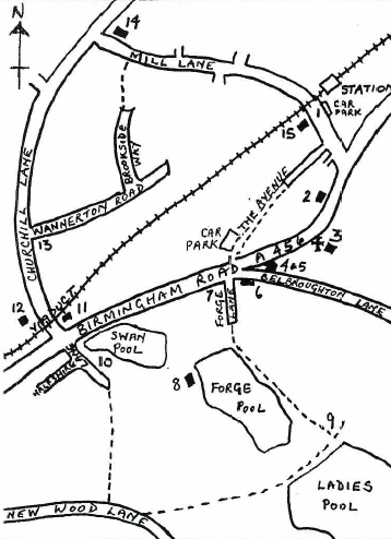
START at Section 1. Leave the village via Station Road, go over the bridge and to the end of Brake Lane, to O.S. Explorer 219 889807.

Alternative convenient start points on the circuit loop may be found by studying the map.

Walk up Brake Lane to its end at a T-junction. Turn right and then left onto a wide track which is the North Worcestershire path. Continue to the end to reach a tarmac road with a Staffordshire boundary sign opposite.Hagley Railway Station

Cross this road which connects Churchill to Iverley and climb a stepped track. At the top turn left on a signed path and follow the left hand hedge. There are wide ranging views to your right.

Drop down to cross the road from Stakenbridge and follow f.p.s. heading towards Churchill, keeping to the left hand hedge to a stile. Go a short distance further to another stile, then another by a concealed bungalow. Keep to the field boundary left, then cross a stile and turn right to emerge opposite Churchill Church.

Cross the road, turn left and go 200 yards to take the second bridge on the right. Then immediately turn left on a signed path to a stile, followed by a KG. Walk alongside the stream to a stile. This leads to a hedged path between properties and emerges on a track.

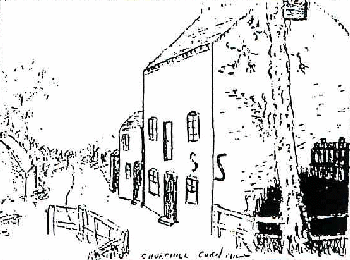
At the T-junction take a 50yds detour left to see Churchill pool and then Churchill Forge. An explanatory board is on your left..Churchill Church

Retrace your steps and then continue on through a gate and walk ahead on the same line over a field to the railway. Cross the level crossing with care. The noise of the traffic on A456 is now evident. Continue ahead to a hedge, over a stile onto the A456 and turn left to a stile 20 yards on the right. Cross this busy road with care and take the signed path running SE over a field to a signpost. The path then runs between pools with a house on your right. When you reach an open field turn right and in 10 yards turn left across a field to reach a gap in the hedge with a f.p.s at the edge of a wood. Turn left behind the hedge for 10 yards then turn right and follow the path uphill. Continue on this path which leads to the A450. This is a busy road; take care when crossing.

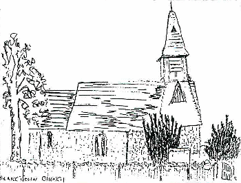
The path goes via the gap in the fence opposite the lay-by and runs N.E. over the rise to drop down at the end of a farm track onto the road into Broome. Turn right and right again at a signpost to Broome. Pass the Church and continue ahead on a ‘No Through Road’ to a T junction. Turn left and continue to a gate. Then follow the left hand hedge with the Clent Hills in full view ahead. After ¾ mile, at a lane turn right and after 100yds look for a path on the left up a bank of 9 steps. Go right between hedges with a wire fence on the right. This is a long stretch and in season has good views of Hagley on the left. Ignore the left fork then the reach the road via a property – the path runs between hedges on the right and not via the drive. At the road turn left and after 50 yards take a path which goes through a KG by a cottage on the right. Walk with the stream on your right through another 3 KGs. Keep right, go over a plank bridge crossing the stream and walk past a hedge corner jutting into the field and continue to another gate at Church Avenue. Cross over the road, turn left and go under the road bridge. Continue up to Clent Church.

Continue on Section 2. Go ahead up Vine Lane to The Vine public house. 50yds after ‘The Vine’ look for a steep path on the right. Cross a stile by an N.T. sign and when the track joins a wider one on the left, turn left and continue to climb up the high path. Keep straight on walking up and around the side of the hill, until you reach the O.S. Trig. Point. From here continue ahead straight through a small open area with benches and straight on down a narrow path through trees. Cross a track, and the path then shortly joins a lane. Turn left and pass Walton Hill car park. Walk along the lane to a T junction by High Harcourt Farm. Turn left into St. Kenelm’s Pass and then right onto the North Worcestershire path, passing a gate and walking uphill. Bear left and climb to the highest ground, ignoring any side paths. At the top on your left are the Four Stones and the Toposcope erected by Stourbridge and Kidderminster Rotary Clubs. Take in the wonderful views all around and look north to see the Castle and Obelisk which are your next objectives. Descend right of a clump of trees and go straight on leaving the visual display plaques on your right. (Avoid the two tracks on your right). The descent is steep and when you reach a cross path take the path to the right, leaving the North Worcestershire path. A house behind a hedge is soon visible, then the castle is can be seen further behind. Turn right along a broad track, past a Private No Cycling sign. Bear left and then right on leaving woodland. The timbered Badger’s Sett public house and Obelisk come into view..

In the distance are Sedgley Beacon and Dudley Top Church. At a broad track on the left before the power lines, turn right to cross a stile and then another to reach the A456. Go left to just past the Old Rectory and use the tarmac path as the point for careful crossing of this busy dual carriageway.

Continue on Section 3. Opposite the island is a stile below road level. Keeping close to the fence on your right, proceed to the wood ahead, passing the restored Obelisk on your left. Go through a KG and continue ahead passing through the wood for a birds-eye view of Stourbridge and beyond. Carefully descend the well used and often slippery path through a KG onto Pedmore Lane. Turn left to reach a busy island, go past the Foley Arms public house, use the pedestrian crossing to carefully cross the A491, turn right then left into the bridleway just after Pedmore Convenience Stores. This passes by modern properties, then past a school and between houses. At the T junction turn right continuing along a bridleway, across Redlake Drive and onto Worcester Lane. This is a busy road; cross carefully and then straight over the railway bridge passing very substantial houses. At the tarmac roads go straight ahead to eventually reach a T junction. Turn left and go past the Ounty John Lane Severn Trent site. Take the next turning right. This becomes a sandy track and drops down to a junction of tracks. Turn left after Norton Sewage Works onto a Roman Road which may be very muddy in parts and go straight ahead to reach a tarmac road (Brake Lane). Turn left to soon return to the start.

Hagley Historical and Field Society hopes that you have enjoyed this walk which was published in March 2016.

DOWNLOAD THIS WALK Adobe Download